The Knowledge
 This week in The Overspill (which I highly recommend), the veteran journalist Charles Arthur highlighted a piece by Justin O'Beirne that compares the 2010 and 2016 versions of Google's maps, and concludes they're both flawed, in opposite ways. In 2010, O'Beirne shows, Google optimized for place names over road density, leading to many "orphan cities" - that is, cities marked on the map but lacking a visible route of access. Today, Google optimizes for showing roads at the expense of place names and labels, so that until you zoom in closely all you see is a tangle of unidentified spaghetti. O'Beirne theorizes that Google is optimizing for mobile devices, but I suspect it's more specifically for satnavs (and self-driving cars), for which labeling and other details like one-way systems is less crucial. Most people just want to know their next move. On mobile phones, I suspect, maps are more often used as zoomed-in guides to show what's nearby.
Arthur also highlighted Nick Carr's follow-up piece, which concludes that we are shifting map-reading from man to machine and acquiring a universal map just when it's no longer needed. A better characterization is that we are beginning to build piles of data describing the physical world that someday could be output as a map for any purpose on any medium. This is only in its infancy. Today's online maps are functionally terribly limited: they calculate directions between two points, but can't optimize a route for multiple errands. My preferred map, OpenStreetMap, gives the helpful ability to select overlays such as cycle routes and transport links as needed. In an ideal someday world, that concept should expand to many other uses. Tourists exploring, for example, want something very different than someone who abruptly needs an alternative route to work.
I'd rather learn the geography, as I wrote a few years ago, but I recognize that I am not normal.
A couple of years ago, as part of convincing me to take up the death-match sport of cycling in central London, a friend insisted I should use Cyclestreets, which plots optimal cycle routes for a variety of ability levels. You can set up Cyclestreets on your mobile phone so that it issues satnav directions via an earpiece. But I didn't want that: routes do not stick in my brain when I follow other people's directions and a dictatorial voice in my ear is distracting. The number of stories of people blindly obeying their satnavs and driving into oceans, off bridges, and onto too-tiny mountain paths suggests this is an all-too-common problem. This may say something about the limits of human brains to cope with cognitive load. Trusting the system and studying the landscape to match its instructions seems to fully occupy the mental capacity that otherwise could note landmarks and form images and guide me independently through a second run.
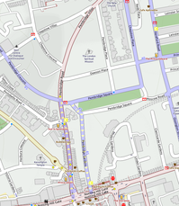
 One of the first things I noticed when I began visiting London in the 1970s was that every single parked car had an A-Z map book in view. In this insanely complex city, streets change names every block or two - or loop back in on themselves without changing it at all. Cyclestreets' directions to travel the four miles from Euston Square to Notting Hill Gate include 37 different street names, some of which are near-identical variations of both themselves and other nearby roads. Casual sloppiness easily confuses Pembridge Villas, Road, Place, Square, and Gardens (two of these), which sound more different than they look when a car is honking behind you at an intersection. The amount of stopping, checking, and looking up the next few turns means every new trip like that takes at least double the estimated time. The payback is knowing the way the second time and beginning to turn London from a jumble of tube-linked neighborhoods into a navigable whole.
This is not, as some have suggested, trying to recreate The Knowledge, the famously comprehensive mental atlas of London street that black cab drivers must master to qualify for a license. The Knowledge, Jody Rosen wrote in 2014 for the New York Times magazine, includes more than 25,000 streets *and everything on them*, so that drivers know every location any picked-up passenger might name. Rosen's question was, does The Knowledge still matter in the time of GPS? By January 2016 the training school Rosen profiled had barely escaped closing, blaming Uber and high rents.
 The Knowledge is a good start on that universal pile of data, but it must be painstakingly installed one brain at a time, with, interesting effects on the hippocampus. It's unsuitable for my purposes, since cab drivers rarely use bike paths or crossings. But I want, like them, to be able to adaptively change routes in response to traffic, construction, or flooding. Similarly, O'Beirne's snapshot of (I recognize it as) a AAA road map, though the best of its kind, is wrong for Google's needs. It's designed for maximum efficiency in planning and navigating car trips - and for transferring geographical understanding into human brains. The ultimate goal of paper maps was to enable you to do without them; the ultimate goal of Google maps and satnavs is to keep you dependent on them.
Wendy M. Grossman is the 2013 winner of the Enigma Award. Her Web site has an extensive archive of her books, articles, and music, and an archive of earlier columns in this series. Stories about the border wars between cyberspace and real life are posted occasionally during the week at the net.wars Pinboard - or follow on Twitter.